Products
GERICS Rain Map
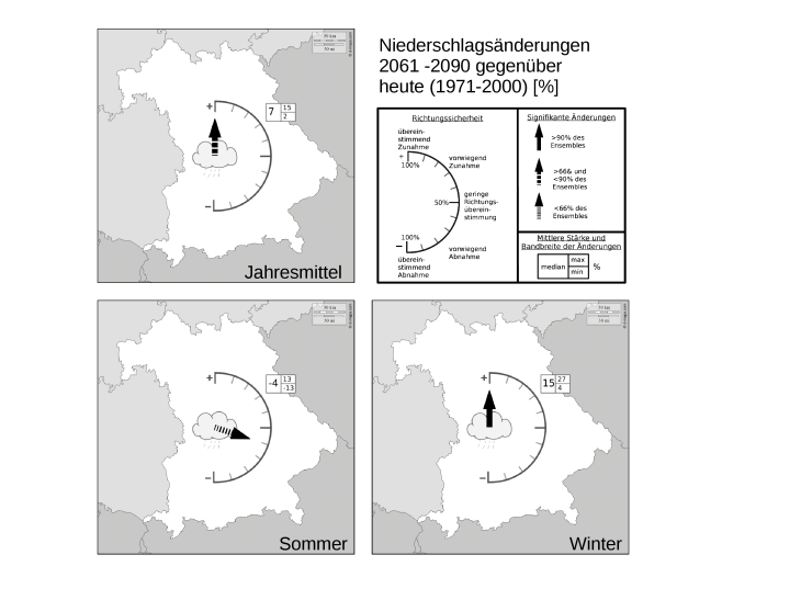
In cooperation with representatives of some of the German Bundesländer, GERICS has developed the Rain Map, a simple, easily understandable visualization of projected precipitation changes. The data base is an ensemble of regional climate projections (e.g. Euro-Cordex). The visualization method can be easily transferred to other climate parameters and regions.
- The (dis-)agreement in the direction of the projected changes among the simulations: The direction the arrow is pointing to indicate the degree of agreement in terms of increase or decrease of precipitation in the future. The scale ranges from „100% agreement in future increase of precipitation“ (arrow pointing upwards) through „low agreement in the direction of the projected changes“ (arrow pointing to the right), to „100% agreement in future decrease of precipitation“ (arrow pointing downwards).
- The direction and strength of the mean changes and the bandwidth of the ensemble: Direction and strength of the mean changes (or the median of the changes) is given by the numbers right of the semicircular arch. Additionally, the bandwidth is indicated by the maximum (top) and minimum (bottom) changes simulated within the ensemble.
- Significance of the projected changes: The fraction of simulations projecting significant changes is given by the appearance of the arrow shaft. A solid line indicates significant changes projected by more than 90% of the simulations, a coarse dashed arrow shaft indicates significant changes projected by only >66% of the simulations and a fine dashed arrow shaft marks less than 66% simulations with significant changes.

The visualization method of the Rain Map can easily be transferred to other climatic parameters and regions.
